Sunday, February 5, 2012

Interference

I keep my Bonanza at a small, private field in McKinney TX, called AeroCountry (T31).  It has one runway, a strange combination of grass and concrete.  The Northern end is 1,300 feet of grass, the Southern end is 3,000 feet of concrete, for a total length 4,300 feet.  The join is pretty well done - I've landed on the grass and taxied onto the concrete and there's just a small bump.

No instrument approaches, however.  Many of the aircraft there are smaller experimental types, and some exotic aerobatic aircraft (the hangar next to mine holds a Yak 26).  Until recently, the runway was too narrow to meet the FAA requirements to have an IAP (Instrument Approach Procedure), but when a developer wanted to buy the East side of the airport and put up luxury condos and attached private hangars, part of the deal was that he would pay to re-develop the runway, making it wider.  Now we can have an IAP developed, and I'm pushing the owners council to ask the FAA to make a GPS IAP for us.  Otherwise in bad weather I have to land at Collin County Regional (KTKI), about 8 miles away.

Of course in order to fly a GPS approach, the aircraft must have a working GPS unit, certified for IFR operations.  My Bonanza has a Garmin GNS 430W, certified for precision approaches down to 300 feet AGL (or down to 200 in ILS mode), an Apollo panel mounted GPS without WAAS (for navigation and non-precision approaches, I usually just leave it turned off), and a handheld Garmin 496 in a mount, which is used for navigation, backup, and Nexrad weather radar display.

The trouble is, that they all have to receive satellite signals, and these signals come in on a variety of microwave frequencies, around 1.5 GHz.  Paradoxically, the most capable of the 3 GPS units in my Bonanza is also the most sensitive to interference - the 430W needs 5 working satellite signals to be able to support a precision approach.  The 496 only needs 3, but it can't be used for approaches.  And somewhere near T31 is an interferer that is blanking out all GPS use.

Garmin GNS 430 W


Some of the pilots thought that someone had put up a 1.5GHz base station on a nearby water tower that doubles as a cell site, having read about the issues with Lightsquared and the FCC.  Others suspected a nearby radar test range owned by Raytheon.  And a few suspected a microwave relay tower furtehr to the southwest owned by AT&T.  Since I work in wireless telecommunications and am an FAA licensed flight instructor, I know how to work with both the FAA and the FCC and have the contacts to make something happen.

Eventually the FCC agreed this was their baby, and sent out a technician to track down the source.  He drove around where the pilots said we all lost GPS, and found nothing.  So he called me, and I agreed to take up my airplane and try to narrow down the source.  I took off one Saturday with a friend in the right hand seat, and we flew all around the field at 600 to 700 feet AGL (the FAA requires at least 500 feet clearance above or laterally from any obstacle, building, person or vehicle).  We flew various legs around the field, and proved that the source was not the cell tower, the radar range, or the communications tower.  It appeared to be a circle centered near a road intersection.


Based on where we lost GPS lock, the FCC drew up a map showing the 2 circular patterns that best fit the data, and concluded that interferer is near the intersection of Westridge and Independence roads, in a newly built neighborhood.  They asked me to do some more runs from the West and South to confirm the circle's radius, but now suddenly the interferer has gone, after 4 months.  Vanished. Poof!

The FCC's best guess is that it's a bad HDTV adapter in someone's home.  It seems that some can fail in a way that radiates in the GPS bands - at least one model has been recalled, but there are still some out there.  I wish we had found it - it worries me that the GPS blank spot could come back at any time.  Unless the perpetrator knew what he was doing and realized that someone in an airplane was trying to track him or her down - Chinese spy satellite radio, anybody?  Although the usage pattern is closer to that of the TV adapter, staying on for days and weeks at a time - maybe they went out and bought an HDTV and threw out the old analog one.  Still, before we can get a GPS IAP, it needs to be resolved.

This is why your instrument instructor told you to monitor the GPS unit's satellite lock throughout an approach - it can just vanish.  Then what will you do?

Monday, January 2, 2012

Action Photos

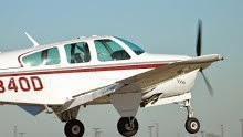
Last week I took Thing 1 with her very nice camera to Caddo Mills (7F3), and dropped her off near the runway.  I then took off, and made some low approaches while she took my picture.  Here are two of the best (that don't show the "N number").......


Tuesday, December 27, 2011

Year End Review

Thanks to Gary, who gave me the idea for this post.  My 2011 in review:

January: Only 1 flight, some touch and goes in the pattern to keep my hand in

February: No flying AT ALL.  But I did take Sally with me on my annual trip to Spain for Mobile World Congress in Barcelona, which made it much more fun.

March: Started looking for a bigger, faster airplane, a Bonanza, and almost instantly found one (on BeechTalk) at Addison, a 1968 model V35A.  Went for a test flight and loved it,  dropped my original plan to buy an A36 and sell a 50% partnership in favor of a less expensive, but almost as capable airplane that I can own outright.

April: Took delivery of "Bo", and started training to remove the insurance restriction requiring 10 hours of dual and 5 hours of solo before carrying passengers.  Also started a 4 week CFI course at American Flyers, flying their simulators and a C172RG.  Decided to use my Sundowner instead, which I posted for sale on the BAC site and BeechTalk.

May: Took (and passed) the CFI Instrument written and practical tests (in the Sundowner), as well as the Ground Instructor (Instrument) test.  Took a 4 week break in the middle of the American Flyers CFI course to get some regular work accomplished.  Also knocked out about half of the Bonanza time needed.

June: Finished the required hours in the Bonanza, and the American Flyers course.  Took (and passed) the CFI Airplane written and practical tests using both the Sundowner and the Bonanza, as well as the Advanced Ground Instructor license.  Started my first Student, another Sundowner pilot who wants to get his instrument rating.

July: Moved the Bonanza from TKI to T31, renting a private hangar there.  Gave a student transitioning his first high power retract instruction (he later bought his own A36 Bonanza).

August: Got laid off from work, and sold the Sundowner after completing a fresh annual inspection.  Did my first Instrument Proficiency Check (IPC) in a Mooney.

September: Flew Sally and Thing 2 to Longview TX to watch a high school football game, where Thing 1 was playing in the band.  Everyone else suffered a 3 or 4 hour drive - we enjoyed a short 45 minute VFR flight in the Bonanza and a free crew car from the FBO there.

October: Planned to fly the Bonanza to Chicago to attend 4G World and network, but instead flew commercial using miles for reliability and predicatbility.  Met the guy who became my new boss in -

November: Started my new job, and flew to Florida and the UK for on-boarding.  Over Thanksgiving, flew with Sally and both Things to Phoenix to visit relatives. getting my first experiences of mountain flying and real world icing.

December: Got settled into my new job, and hardly flew at all due to bad weather and Christmas preparations.

So, quite a year!  120 hours in the air, sold one plane and bought another.  Got 4 new ratings (CFI-A, CFI-I, AGI, IGI), and did one long cross country under new conditions.  Did my first paid-for commercial flying (as an instructor), lost one paying job and started another.  I'm hoping 2012 will be a little less "interesting"...........

Monday, December 19, 2011

New Picture

Saturday was a great, typical Central TX kind of day - Sunny and cool at 55 degrees.  On landing back at T31, I saw 3 guys taking photos from the side of the runway.  One of them sent me this......

Wednesday, November 30, 2011

Leg 5 - into the storm

OK, so it wasn't really a storm, but it was something of a first for me.

After filling the Bonanza and emptying our bladders, we started up the hot engine on the second attempt, and taxied out to runway 14 for take off.  At the FBO, I had pulled up fltplan.com and check "file this" against the flight plan already entered, KPEQ direct T31.  The weather was VFR, but with rain clouds catching up from El Paso.

At 4,000 feet, I called Forth Worth Center - "Ft Worth Center, Bonanza 40D is out of Pecos, 4,000 climbing to 7,000, IFR to Aerocounty, T31.  Request my IFR clearance".  "Bonanza 40D, Ft Worth center. Cleared to T31 as filed, climb and maintain 9,000, squawk 1234.  Be aware there is light to moderate rain ahead near Midland".

Continuing the climb, I noted that there was cloud above, so I request to remain at 7,000 - "Ft Worth center, Bonanza 40D.  I'd like to stay at 7,000, if able".  "Bonanza 40D, Ft Worth Center.  Maintain 7,000 feet".  The 496 showed the weather ahead in splotches of light green, dark green and yellow, depicting light rain, light to moderate rain, and moderate rain.  Our flight path, which passed just south of Midland, went though one of the lightest, most narrow sections of a long line of weather reaching up into Oklahoma and down into Mexico.  By this time I was handed off to Midland Approach, which only seemed to be working 2 other aircraft, a Mexican business jet and a Southwest Airlines departure.

I asked for unrestricted maneuvering and for an altitude block from 5,000 to 7,000 feet.  I could see under the rain clouds quite well, about 10 to 15 miles.  I slowed down in case of turbulence, and entered the rain shaft.  The 496 showed that the patch just off my right side was strengthening to yellow, so I steered a few degrees left, and after a short while I saw that the sky ahead and to the right was lightening, so I steered that way, and we came out into the sunshine at 6,500.  I climbed back to 7,000, and when prodded by approach I confirmed I no longer needed the altitude block, and was cleared to maintain 7,000.

The flight under the clouds was slight bumpy, but not really any more than a clear summer day in Texas below the summer cumulus.  We were now in a clear patch, but halfway to the next layer of clouds we hit some moderate clear air turbulence, probably the actual weather front which was clearing the clouds ahead, and forming rain behind.  As the clouds were at my height, I asked for 9,000 feet, which was assigned.  As I climbed, I was handed of the Ft Worth Center again, and they asked my if I could copy a DFW arrival clearance.  "Standby", I replied, as I hand flying and wanted to get back on autopilot to free my hands and brain.  "Ready to copy".

I read back the new clearance: "Bonanza 40D direct Tuscola (TQA), V94 (again!) to Glen Rose (JEN), via the Glenn Rose 064 radial, then the Cowboy (CVE) 213 radial to Cowboy VOR, expect radar vectors to Tango 31".  Why they didn't just say after JEN, direct KNEAD intersection, direct CVE is beyond me, but that's how I entered it into the 430W.  A few minutes later, the clearance was amended to direct KNEAD, direct CVE, then after 20 more minutes, just direct KNEAD direct T31.

On reaching KNEAD, I was given a heading of 050 degrees, and told to descend to 5,000.  This put me directly in a layer of cloud as we flew over Midlothian and Ceder Hill.  I asked to descend to 4,000, but that didn't happen until we were approaching Lancaster airport.  Finally permitted to turn toward my destination, we first flew on a heading of 030 toward Mesquite, then over Richardson and Plano heading 350.  Passing over the Bush Turnpike, I cancelled IFR and flew to T31, landing on runway 35 just before 5pm.  Luckily that just left time to put away the plane and drive like Hell to the vet, and get the pets out of the pokey before they closed at 6.

Well, what a flight!  I was quite proud of myself, it stretched my experience (but not my skills).  I should have expected the icing, but it took me by surprise, and caught me without the pitot heat on. But I thought I handled the situation well, working with ATC to get to a good solution. I would not have liked to do that flight in my old Sundowner - it would have had nothing left to give at 12,000, if it could even get there.  The Bonanza could still climb at more than 500ft/min all the way to 12,000.  I still have a radio problem brought on by moisture, but in dry conditions it works just fine.  And the V35A is the fantastically capable, fast cross country machine that I was looking for.

Leg 4 - No ice for me, thanks

Time to head home, turkey and stuffing consumed, relatives visited.

Friday November 25th was a sunny day in Phoenix, high around 60, light to no wind.  I planned/hoped to take off around 9:30am, and tried to get everyone up and going on time, but to no avail.  We left the house in Mesa at 9:15, and got to CHD at 9:45.  I paid for the fuel and tie down, and taxied 40D over to the terminal at Chandler Air Service to load up.

The weather over the mountains of Southern Arizona and New Mexico was forecast to be scattered cloud, with showery rain from El Paso to mid central Texas.  Going back on V94, I expected that IFR I would be assigned 11,000 feet, and since Sally had shown some symptoms of altitude sickness at 11,000 on the way up, I decided to go VFR so I could fly at 9,500.  It also had the advantage that I could get out of the busy Phoenix area without worrying about terminal flow control and delayed IFR releases.

Bonanza's, like all high powered aircraft, can be difficult to start when the engine is hot.  This one was warm from the short taxi, and I wasn't sure which technique to use.  I decided to use the hot start technique, and start without priming, but to "goose" the electric pump as the started engaged.  This usually works well.......

The engine did not want to run.  It would fire, fire and stop.  Thinking that too little fuel was the problem, I tried again, running the pump longer, until another pilot came over waving his hands over his head, and told me that fuel was pouring out of the engine cowling.  The engine was flooded.  I shut everything down, we pushed the aircraft backwards away from the fuel puddle, and went to the Airport Cafe for a coffee while we waited for the spill to evaporate.

At 10:30, we loaded up again, and using the technique for a flooded start, I got the the engine running.  I called ground, and got taxi clearance to runway 22 Right, did my pre-flight checklist, and off we went, turning left to a course of 113, direct ITEMM.  I chose ITEMM as being a waypoint on V94 that avoided the military's airspace over the Superstition mountains, yet got onto the airway as far East as possible.

I had been watching a bank of clouds to the south East all morning.  As we drove to the airport, they were quite close, a solid overcast at what I estimated to be around 7,000 feet.  During all the faffing around at CHD, the clouds retreated southeastwards.  I assumed they would break up over the mountains, as forecast.  Now, as we turned towards the southeast, I could see that they were still a solid bank, but that we would be above them at 9,500.  VFR pilots can fly over a solid undercast of clouds, but it's wise to either know for sure that you can get down again visually somewhere ahead, or be instrument rated and have a backup plan.  I had both options available.

I called Phoenix departure and asked for VFR flight following, a halfway house where the pilot flies to VFR rules and must maintain VFR conditions (1,000 feet above, 500 feet below and 2,000 feet horizontally seperated for clouds, with 3 miles visibility), but communicates with air traffic control, who provide (on a time permitting basis) traffic reports and other assistance.  Initially, things were looking good.  The clouds topped at about 8,000 feet, and I reached ITEMM as planned, and turned toward SSO VOR.

The cloud tops kept rising, and eventually I realized I would not be able to maintain VFR.  I called ATC, and was given an IFR clearance along V94, direct SSO, direct DMN, direct EWM (Newman/El Pase) direct Pecos (PEQ).  Climb and maintain 11,000 feet (as expected), and squawk 1234.  I did so, and we cruised comfortably above the cloud base.  But it kept rising, and over Bassett Peak, we were solidly in the clouds.

"We're getting ice!" said Sally.  I looked at the wings, and said "I think it's just rain", but 30 seconds later I changed my mind, and called Albequque Center to tell them and ask for a climb to 12,000.  I got the climb right away, and Center asked me what the outside air temperature was and what type of ice.  I looked at the OAT gauge,and read back "1 degree", and not knowing much about ice (yes, I know I'm a CFI-I, but I'd never seen it for real), I said the first thing that came to mind "light rime ice".

It wasn't, and maybe center knew, because she asked me again.  I said the same thing, but I now know that rime doesn't form until 10 to 20 degrees below freezing, because once on the ground I looked it up.  This was clear ice, caused when supercooled droplets near +2 to -5 degrees hit the cold airframe and freeze on it.  Rime ice starts out already frozen, and looks milky.  The fantastic Bonanza climbed strongly to 12,000 (a new personal altitude record), where we leveled off in clear air, and the ice slowly sublimed away.  At this point I remembered to turn on my pitot heat, which should have been on before I entered any cloud at that temperature.  Learning experience!

After 5 or 10 minutes, the cloud tops reached 12,500, and we were back in clouds, with more icing.  Since we were now past the highest ground under the airway, I asked center for a lower altitude (I didn't want to go higher without oxygen, although the colder, denser air seemed quite breathable), and was assigned 9,000 feet, just as the clouds suddenly broke up and the tops fell way below us.  "40D would like to remain at 12,000 now, the cloud tops are below us".  "Bonanza 40D maintain 12,000 feet".  I asked for a clearance to deviate around the few remaining tops, and was cleared to deviate up to 30 degrees left, and right to no more than a heading of 100 degrees (to avoid the surveillance balloon near the border area with Mexico, I assume).

Just before reaching El Paso, the clouds started to break up, so I asked for 9,000 feet, and descended to pass over EWM (Newman/El Paso) VOR at 9,000.  On the Garmin 496 handheld GPS, the next challenge began to show ahead - patches of green representing light rain. ATC re-routed me over Salt Flats VOR (SFL), but that was pretty much on my direct path anyway, then they issued a heading direct Pecos, so I jumped ahead on the running flight plan on the Garmin 430W, and selected direct KPEQ.

Between us and Pecos were scattered showers, with clouds down to 6 or 7,000.  I asked for 7,000, and to deviate around weather, and was given unrestricted maneuvering - I suppose there was little other traffic on that US holiday.  After clearing the last shower and taking a few moderate bumps at maneuvering speed (130 kts in my Bonanza at gross weight), I cancelled IFR, and called Pecos unicom.  A soft female voice gave me the weather, and announced no other reported traffic.  I touched down on runway 09 at around 2pm, a nice 2.5 hr flight with an average ground speed over 200 mph.

Monday, November 28, 2011

Leg 3 - The High And The Mighty

Leg 3 - Going where I had never gone before.

After a quick meal at Chili's, I paid for the expensive gas at Cutter, and we loaded up the Mighty Machine.  I called clearance delivery, and proceeded through a comedy sequence with the controller, who started with "ATC clears 40D to Chandler.  After take off, direct MOLLY, V94 to dem----- mush mush something something."  Every time he tried to give me a clearance, someone else started talking in the background and I couldn't hear it.  This happened about 3 or 4 times, until finally he just gave me a squawk code and told me to contact ground for taxi clearance.

Receiving clearance to cross runway 26 Left, I stopped at the hold short line for Runway 08 left, and was cleared for take off - taking off on the same runway I had just landed on, but going the other way.  The Bonanza handled slightly differently at nearly 3,000 foot field altitude, but I was expecting it - a longer take off run, less sprightly initial climb and an engine that needed aggressive leaning to be happy.  I was turned left to 330 degrees and told to contact departure.  I did so, and asked that controller to repeat my clearance.  It was "Direct MOLLY, V94 to Deming VOR (DMN), San Simon (SSO) and Stanfield (TFD) VORs, then direct Chandler, climb and maintain 10,000 feet".  PHEW!  I got this all programmed into the Garmin, and engaged the autopilot, leveling at 10,000 just before reaching MOLLY.

Along the initial part of V94, the mountains west of El Paso safely below, I was advised of opposite direction traffic at 9,000 feet, which turned out to be a De Haviland Dash 8 airliner.  It went past below me with an impressive closing rate - me doing 170 kts, and him over 200.  Cool!

After San Simon, the terrain became a little sporty.  V94 crosses Bassets Peak, with it's peak at 7,666 feet - it feels much closer than 2,334 feet away, let me tell you!  I over-rode the GPS to edge a little to the right where the peak was less "peaky"......  Around this time, ATC called to change my clearance, adding "after Stanfield, V105 to PHX, then direct Chandler", then handed me off to Phoenix approach.

It was starting to get rather twilighty - not yet dark, but on the way.  I really wanted to arrive with daylight remaining - there are lots of mountains around, one of which claimed the lives of 6 people in a Turbo Commander the very next day.   I asked approach for a clearance direct to Chandler, and after a short delay they gave it to me.  So I didn't get as far as Stanfield VOR, instead I headed northwest, descending over the mountain south of Chandler, and was given a visual approach to runway 4L.  But once I was handed over to the tower, they changed my clearance to 04R for traffic, a twin that flew under us in the base to final turn.  Finally aligned with the runway, and still high and fast, I pulled the power way, way back, lifted the nose to slow, and dropped the gear to add drag.  The extra drag took care of my excess speed, and once I was slow enough, I dropped full flaps, and made a picture perfect landing on the runway just as the sun disappeared in the West.

3 legs, 5.7 hours total.  About .6 hours in IMC, all of it IFR, and my first experience of mountain flying.  Not a bad day!